
169 AC Manhattan Industrial Package
| Status: | Active |
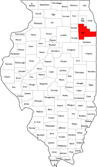
| County: | Will |
| Township: | Manhattan |
| Address: | 0 W Pauling Road Manhattan IL 60442 |
| Gross Land Area: | 169.00 |
| Hectare Conversion | |
| Property Type: | Industrial Development Land, Transitional, Farmland |
| Possible Uses: | Industrial, logistics, data center, warehouse |
| Total Investment: | Contact Broker for pricing |
| Productivity Index (PI): | 122.6 |
| Buildings: | No Buildings (vacant agricultural land) |
| Utilities: | Power adjacent (ComEd substation + Lincoln plant); water/sewer via Village |
| Zoning: | A-1, Agricultural (Will County, unincorporated) |
For more information contact:
Mark Goodwin
1-815-741-22261-815-741-2226 mgoodwin@bigfarms.com
Goodwin & Associates Real Estate, LLC
is an AGENT of the SELLERS.
property alerts
Be alerted to new listings, changes in current listings, and closings as a way to keep your finger on the pulse of the land market.
Property Overview
±169-Acre Industrial Development Assemblage — Manhattan Township, Will County
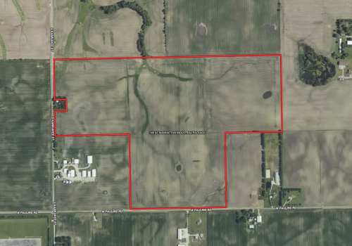
A rare ±169-acre, four-parcel assemblage on the south edge of Manhattan, Illinois, fronting W Pauling Rd and S Kankakee St directly across from the Lincoln Generating Facility and an adjacent ComEd substation. The site combines high-quality, income-producing farmland with a location profile that aligns with the Village of Manhattan's stated priority for new industrial development near existing power-generation infrastructure.
Property Highlights
- ±169 acres (167.41 ac per PLSS/FSA) across four contiguous parcels under three ownerships, offered as a single development assemblage
- Nearly all tillable — weighted Productivity Index of 122.6 on Elliott and Ashkum silt loam soils (approximately 80% of the site)
- Directly adjacent (west, across S Kankakee St) to a ComEd substation and the ~656-MW Lincoln Generating Facility — a major existing power-generation asset on the PJM grid
- Frontage on W Pauling Rd, one of the three corridors the Village identifies as Manhattan's existing industrial areas
- Approximately 1,320 ft of frontage on S Kankakee St and an estimated 1,320–2,640 ft on W Pauling Rd
- Outside the 500-year floodplain — 100% FEMA Zone X (minimal flood hazard)
- Nearly level to gently undulating topography (26 ft total relief across the site)
- Currently zoned A-1 Agricultural (unincorporated Will County); annexation and rezoning to a Village industrial classification would be required for development
- Approximately 3 miles southeast of downtown Manhattan and the Manhattan Metra station (SouthWest Service)
- Approximately 12 miles northwest of Joliet and 37 miles south of downtown Chicago
Land Characteristics
The assemblage is composed almost entirely of productive cropland. The dominant soils are Elliott silt loam, 2–4% slopes (57.1% of the site) and Ashkum silty clay loam, 0–2% slopes (22.7%), with smaller components of Varna silt loam and Peotone silty clay loam. The site carries a weighted crop productivity index of 122.6 (Illinois Soils EFOTG, Bulletin 811). Topography is nearly level to gently undulating, ranging from approximately 693 to 719 feet of elevation with about 26 feet of total relief. A natural drainageway crosses the central portion of the assemblage, and the National Wetlands Inventory maps approximately 7.04 acres of freshwater emergent wetland within the boundary. The entire site lies within FEMA Zone X (an area of minimal flood hazard, outside the 500-year floodplain). The included Surety soil, topography, wetland, and FEMA maps detail these features.
Location, Access, and Infrastructure
The assemblage occupies the south-central and southwest portions of Section 26, Township 34 North, Range 11 East, bounded by S Kankakee St on the west and W Pauling Rd on the south, immediately southeast of the Village of Manhattan. Its defining feature is power: the property sits directly across S Kankakee St from a ComEd substation and the Lincoln Generating Facility, a natural-gas generating station with approximately 656 MW of capacity serving the PJM market. Proximity to existing substation and generation capacity is among the most significant factors in siting energy-intensive industrial and data-center uses across the Chicago–Will County market.
Regional highway access is via U.S. Route 52 through Manhattan (approximately 3 miles northwest); Interstate 80 via Joliet and New Lenox (approximately 12 miles northwest); and Interstate 57 via the Peotone interchange (approximately 9 miles southeast). The Manhattan Metra station (SouthWest Service) is approximately 3 miles northwest, and Norfolk Southern operates freight rail through Manhattan. The CenterPoint Intermodal Center near Joliet/Elwood — one of the largest inland ports in North America — is approximately 9 miles west.
Electric service and a ComEd substation are immediately adjacent; natural gas is in the area. Municipal water and sanitary sewer are not currently extended to the site and would require coordination with the Village of Manhattan as part of any annexation and development.
The site is currently unincorporated and farmed under Will County A-1 Agricultural zoning. The Village of Manhattan's 2025 Comprehensive Plan identifies industrial as a future land use to be "prioritized near existing industrial land uses such as the Lincoln Generating facility," names W Pauling Rd among the Village's existing industrial corridors, and designates the Village's Southern Growth Area for a mix of uses that includes industrial development. Development would require annexation to the Village and rezoning to an industrial classification; this listing presents an opportunity, not an entitlement. Prospective buyers should confirm all zoning, annexation, utility, and entitlement matters directly with the Village of Manhattan and Will County.
Schools
The property is served by Manhattan School District 114 (grades K–8) and Lincoln-Way Community High School District 210; Manhattan students attend Lincoln-Way West High School in New Lenox.
Positioning
Large, contiguous, nearly level parcels with existing on-site power infrastructure next door are increasingly scarce in the Chicago metropolitan industrial market, where substation and generation capacity have become primary site-selection constraints. This ±169-acre assemblage pairs that infrastructure adjacency with productive farmland that generates income during the entitlement and holding period — positioned in a community that has explicitly identified this corridor for future industrial growth.
+ View Brochure
+ View Property Disclaimer and Disclosure.
 |
Property Notes
Additional Resources
- Village of Manhattan — official website
- Will County Land Use Department (zoning & annexation)
- Manhattan School District 114
- Lincoln-Way Community High School District 210
- Manhattan, IL demographics (Census Reporter)
- Village of Manhattan 2025 Comprehensive Plan (PDF)
- Village of Manhattan Official Zoning Map (PDF)
Property Map
Listing Details
General Information |
||
| Listing Name: | 169 AC Manhattan Industrial Package |
|
| Tax ID Number/APN: | • 14-12-26-300-007-0000 — Flora L. Gallagher — NW¼ SW¼ (±39 ac) — centroid 41.40185, -87.93880 • 14-12-26-300-003-0000 — Armand R. Martell — E½ SW¼ (±80 ac) — centroid 41.40110, -87.93405 • 14-12-26-400-001-0000 — Gallagher Michael S Trust — NW¼ SE¼ (±40 ac) — centroid 41.40115, -87.92920 • 14-12-26-400-012-0000 — Armand R. Martell — pt SW¼ SE¼ (±10 ac) — centroid 41.39755, -87.93095 |
|
| Possible Uses: | Industrial / manufacturing, warehousing & distribution, logistics, data center / energy-intensive uses (subject to power, water, and entitlement), utility-scale uses, continued agriculture during holding/entitlement period | |
| Zoning: | Currently A-1 Agricultural, unincorporated Will County (minimum 10-acre agricultural lots under the Will County Zoning Code). The site is within the Village of Manhattan's planning area; the Village's I-1 Limited, I-2 General, and I-3 Intensive Industrial districts would be the relevant classifications upon annexation and rezoning. | |
Area & Location |
||
| School District: | Peotone Community Unit School District 207U (grades K–12) | |
| Location Description: | The assemblage lies on the south edge of the Village of Manhattan, in unincorporated Manhattan Township, Will County, bounded by S Kankakee St on the west and W Pauling Rd on the south. It is directly across S Kankakee St (east) from a ComEd substation and the Lincoln Generating Facility. Downtown Manhattan and the Manhattan Metra station are approximately 3 miles northwest; Joliet is approximately 12 miles northwest; and downtown Chicago is approximately 37 miles north-northeast. | |
| Site Description: | Four contiguous parcels totaling ±169 acres (167.41 ac per PLSS and Surety FSA mapping) occupying the south-central and southwest quarters of Section 26-34N-11E. The combined footprint is roughly rectangular with a step at the southeast corner. The site is nearly all tillable cropland, nearly level to gently undulating (˜26 ft of relief), with a natural drainageway crossing the central area and ˜7.04 ac of mapped freshwater emergent wetland. Frontage on S Kankakee St (west) and W Pauling Rd (south). No buildings. | |
| Side of Street: | North side of W Pauling Rd; east side of S Kankakee St | |
| Highway Access: | U.S. Route 52 runs through Manhattan approximately 3 miles northwest. Interstate 80 is approximately 12 miles northwest via Joliet/New Lenox, and Interstate 57 is approximately 9 miles southeast via the Peotone interchange. U.S. Route 45 is approximately 11 miles east-northeast and Illinois Route 53 approximately 13 miles northwest. | |
| Road Type: | Paved township/county roads (S Kankakee St, W Pauling Rd) | |
| Legal Description: | Part of the NW¼ SW¼; the E½ SW¼; the NW¼ SE¼; part of the NE¼ SE¼; and part of the SW¼ SE¼ of Section 26, Township 34 North, Range 11 East of the Third Principal Meridian, Will County, Illinois | |
| Property Visibility: | Visible from W Pauling Rd (south) and S Kankakee St (west); the adjacent Lincoln Generating Facility and ComEd substation are prominent landmarks immediately to the west. | |
| Largest Nearby Street: | S Kankakee St / U.S. Route 52 corridor through Manhattan | |
| Transportation: | Manhattan Metra station (SouthWest Service to Chicago Union Station) ˜3 miles northwest. Norfolk Southern operates freight rail through Manhattan (branch from the Manhattan Metra station serving industry near Bruns Rd). CenterPoint Intermodal Center (Joliet/Elwood) ˜9 miles west. Airports: Lewis University Airport ˜16 miles northwest; Chicago Midway ˜28 miles north-northeast; Gary/Chicago International ˜31 miles east-northeast; Chicago O'Hare ˜40 miles north. | |
Land Related |
||
| Lot Frontage (Feet): | Approximately 1,320 ft on S Kankakee St (west). | |
| Tillable Acres: | Approximately 160 acres tillable (nearly the entire ±169-ac site, less ˜7 ac of mapped wetland and a central drainageway). | |
| Lot Depth: | Approximately 2,640 ft north-south at the deepest point (the E½ SW¼ parcel spans the full half-section depth from W Pauling Rd to the section midline). | |
| Buildings: | No buildings. Vacant agricultural land. | |
| Zoning Description: | Current zoning is A-1 Agricultural under the Will County Zoning Code (unincorporated; minimum 10-acre agricultural parcels). The site is within the Village of Manhattan's planning area and adjacent to the Village's industrial corridor along W Pauling Rd. Development for industrial use would require annexation to the Village of Manhattan and rezoning to an industrial district (I-1 Limited, I-2 General, or I-3 Intensive Industrial). The Village's 2025 Comprehensive Plan supports prioritizing new industrial development near the adjacent Lincoln Generating Facility. This is a development opportunity, not an entitled or "shovel-ready" site; all zoning, annexation, and entitlement matters must be confirmed with the Village of Manhattan and Will County. | |
| Flood Plain or Wetlands: | 100% FEMA Zone X — area of minimal flood hazard, outside the 500-year floodplain (FEMA panels 17197C0320G and 17197C0315G, effective 2/15/2019). The National Wetlands Inventory maps approximately 7.04 acres of PEM1Af freshwater emergent wetland within the boundary. See the included FEMA Report and Wetland maps. A wetland delineation is recommended prior to development. | |
| Topography: | Nearly level to gently undulating. USGS 3-meter DEM: minimum 692.9 ft, maximum 719.1 ft, average 706.8 ft, total relief approximately 26.2 ft, standard deviation 4.36 ft. A natural drainageway crosses the central portion. See the included Topo, Topo Contours, and Topo Hillshade maps. | |
| Soil Type: | Weighted soils across 167.41 mapped acres (Surety / USDA-NRCS, Soil Area IL197 v20): • 57.1% — Elliott silt loam, 2–4% slopes (146B), PI 124 • 22.7% — Ashkum silty clay loam, 0–2% slopes (232A), PI 127 • 9.3% — Varna silt loam, 4–6% slopes, eroded (223C2), PI 109 • 5.8% — Varna silt loam, 2–4% slopes (223B), PI 115 • 2.4% — Peotone silty clay loam, 0–2% slopes (330A), PI 123 • 2.1% — Elliott silty clay loam, 2–4% slopes, eroded (146B2), PI 118 • 0.6% — Elliott silt loam, 0–2% slopes (146A), PI 125 |
|
| Available Utilities: | Electric: ComEd, with a substation immediately adjacent (west). Natural gas: in the area. The ~656-MW Lincoln Generating Facility (Earthrise Energy, PJM grid) is immediately adjacent. Municipal water and sanitary sewer: Village of Manhattan — not currently extended to the site; availability, capacity, and routing to be confirmed with the Village. | |
Financials |
||
| Finance Data Year: | 2024 Tax Year, Payable 2025 |
|
| Real Estate Taxes: | Combined approximately $4,935.48 per year across the four parcels (2024, payable 2025): • 14-12-26-300-007-0000 (Flora Gallagher, NW SW): $1,147.44 • 14-12-26-300-003-0000 (Martell, E2 SW): $2,279.28 • 14-12-26-400-001-0000 (Gallagher Trust, NW SE): $1,200.40 • 14-12-26-400-012-0000 (Martell, pt SW SE): $308.36 |
|
| Investment Amount: | $10,140,000 or $60,000. | |
Location |
||
| Address: | 0 W Pauling Road, Manhattan, IL 60442 |
|
| County: | Will County, Illinois |
|
| MSA: | Chicago-Naperville-Elgin, IL-IN-WI Metropolitan Statistical Area |
|
MARK GOODWIN PROFESSIONAL BIOGRAPHY
It is difficult to find a real estate professional that specializes in Illinois Land Brokerage. Our services area includes Kendall County, Grundy County, Kane County, LaSalle County, Kankakee County, Livingston County, Ford County,Bureau, Henry County, Kane County, Dekalb County, Lake County, Iroquois County, Vermilion County, Kankakee County, and Cook County. Illinois Land Brokerage is a very specialized segment of the real estate brokerage industry. Knowledgeable Land Brokers are difficult to find. Many agents can sell a farm, but how many have the experience and qualifications of Goodwin and Associates?
Mark Goodwin is a Illinois Land Broker who can advise you about your land asset. It takes an experienced Illinois Land Broker to understand how best to market your land asset or find the property that best fits the investors needs or desires. Goodwin and Associates is the Land Broker for you in Illinois. We can help you with the marketing of your farm, residential development land, industrial land and commercial land or help with the selection of farmland, commercial land, retail land, industrial land, residential development land, residential lots, industrial lots and commercial lots. We are here to help you reach your goals.

Mark Goodwin - Illinois Land Broker
1-815-741-22261-815-741-2226 mgoodwin@bigfarms.com
Goodwin & Associates Real Estate, LLC
is an AGENT of the SELLERS.