
104 AC Peotone Farm
| Status: | Active |
| County: | Will |
| Township: | Will |
| Address: | 0 S Will Center Road Peotone IL 60468 |
| Gross Land Area: | 104.86 |
| Hectare Conversion | |
| Property Type: | Agricultural Farmland |
| Possible Uses: | Row crop, hay, pasture, livestock, transitional |
| Total Investment: | $1,457,554.00 |
| Monetary Conversion | |
| Unit Price: | $13,900.00 per Acre |
| Productivity Index (PI): | 123.4 |
| Buildings: | No Buildings — Building site retained by seller, not included in this sale |
| Utilities: | Electric at road; no natural gas (propane standard); well & septic required for any future farmstead |
| Zoning: | A-1, Agricultural District (Will County) |
For more information contact:
Mark Goodwin
1-815-741-22261-815-741-2226 mgoodwin@bigfarms.com
Goodwin & Associates Real Estate, LLC
is an AGENT of the SELLERS.
property alerts
Be alerted to new listings, changes in current listings, and closings as a way to keep your finger on the pulse of the land market.
Property Overview
104-Acre Productive Tillable Farm — Will Township, Will County
Approximately 104 acres MOL of high-PI tillable ground in eastern Will County, three miles east of the Village of Peotone, with direct frontage on a paved county road. The property combines two contiguous Schroeder family parcels (less the building site retained by the seller) into one of the cleaner farm blocks available in the Peotone-Beecher corridor: virtually 100% tillable, no wetlands, no floodplain, and weighted productivity well above the county average.
Property Highlights
- Hard to find Will County farmland
- Excellent productive farm with a PI of 123.4
- Center road is a well-traveled county road
- No buildings included with this offering
- NHEL (non-highly erodible) cropland with no FSA-determined wetland and no CRP encumbrances — FSA Farm 11395, Tract 2468
Land Characteristics
Soil composition is dominated by two highly productive series. Ashkum silty clay loam (0–2% slopes, soil code 232A) covers 41.3% of the field with an EFOTG-adjusted PI of 127. Elliott silt loam (2–4% slopes, 146B) covers another 36.8% with a PI of 124. The balance is Varna silt loam (4–6% slopes, eroded; 12.7% at PI 109), Peotone silty clay loam (0–2% slopes; 7.4% at PI 123), a small inclusion of Elliott silt loam on 0–2% slopes (1.1% at PI 125), and Pella silty clay loam (0–2% slopes; 0.7% at PI 136). The weighted average productivity index across the full farm is 123.4 — comfortably above the typical Will County mean for row-crop ground. Topography is gentle: predominantly 0–2% slopes across the dominant soils, with the 4–6% Varna inclusion concentrated in a single zone visible on the Topo Contours Map. The Wetland Map confirms zero acres of jurisdictional wetland, and the FEMA Report places the entire mapped area in Zone X (Area of Minimal Flood Hazard, outside the 500-year floodplain).
Buildings — Not Included
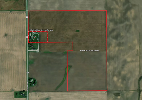
This offering does not include any buildings. The seller is retaining the building site as a carve-out from the original Schroeder parcel; final boundary subject to survey. Marketed acreage of approximately 104 acres MOL reflects the combined parcel area after the building-site carve-out.
Location, Access, and Infrastructure
The farm sits on the east side of S Will Center Rd, a paved well-traveled county road that runs the western section line of Section 22. The Village of Peotone is approximately 3 miles west via E Crawford Rd. Beecher is approximately 5 miles east. The property sits in eastern Will Township, an unincorporated area dominated by row-crop agriculture with scattered farmsteads and small rural subdivisions.
Highway access is anchored by I-57, approximately 9 miles NNE, with the Peotone interchange at IL Rte 50 / Manhattan-Monee Rd providing the closest direct connection. US Route 45 runs north-south through Peotone approximately 3 miles to the west. IL Rte 394 / Calumet Expressway is approximately 11 miles NE for buyers oriented toward the south Cook County / Indiana state-line corridor. I-80 is approximately 20 miles NNE for Joliet- and Indiana-direction logistics.
Utilities at the road: electric service is available along S Will Center Rd. Natural gas is not typical in this rural corridor; propane is the standard heating fuel for area farmsteads. There is no municipal water or sanitary sewer at the property — a well and septic system would be installed by the buyer if a farmstead were ever constructed (subject to A-1 zoning constraints on residential construction). Telephone and rural broadband are available through area providers.
Schools
The property is within Peotone Community Unit School District 207U (PK–12), which serves Will, Peotone, Manhattan, Wilton, Green Garden, and Rockville townships. Schools include Peotone Elementary School (K–3), Peotone Intermediate Center (4–5), Peotone Junior High School (6–8), and Peotone High School (9–12). The district office is at 212 W Wilson St in Peotone.
Positioning / Investment Thesis
This is a clean, contiguous, high-PI farm block in a corridor where the Chicago metro footprint continues to push south. The property functions as productive farmland today — weighted PI of 123.4 with virtually 100% tillable acreage, no wetland or floodplain encumbrance, and good road access — and offers long-term transitional optionality given its position three miles east of a growing Village of Peotone, eight miles from a Metra commuter rail terminus, and within the Chicago-Naperville-Elgin MSA. For an operator-buyer, the income-and-PI fundamentals carry the investment thesis on their own. For a longer-horizon land buyer, the location adds a transitional layer.
+ View Brochure
+ View Property Disclaimer and Disclosure.
 |
Property Notes
Additional Resources
Property Map
Listing Details
General Information |
||
| Listing Name: | 104 AC Peotone Farm | |
| Tax ID Number/APN: | North parcel: 20-21-22-100-009-0000 (less building-site carve-out retained by seller) South parcel (40 AC): 20-21-22-300-003-0000 |
|
| Possible Uses: | Row-crop production, hay/forage, livestock pasture (with A-1 special use), long-term land hold, transitional/rural residential split (subject to A-1 farmstead-split provisions of Will County Zoning §155-2.40(H)) | |
| Zoning: | A-1, Agricultural District — Will County unincorporated. The A-1 district is intended to preserve productive agriculture; permitted uses include agriculture, apiculture, farm buildings, farm drainage/irrigation systems, livestock management facilities (subject to IEPA), grazing/forage, and (with conditions) a single-family farmstead dwelling subject to farmstead-split provisions. | |
Area & Location |
||
| School District: | Peotone Community Unit School District 207U (PK–12). Schools: Peotone Elementary (K–3), Peotone Intermediate Center (4–5), Peotone Junior High (6–8), Peotone High School (9–12). | |
| Market Type: | Agricultural — row crop, with transitional Peotone-corridor optionality | |
| Location Description: | East side of S Will Center Rd in eastern Will Township, Will County, approximately 3 miles east of the Village of Peotone and 5 miles west of Beecher. The property occupies most of the W½ of Section 22, T33N-R13E, combining the S½ NW¼ (less the building-site carve-out retained by seller) with the NE¼ SW¼. Approximately 38 miles south of downtown Chicago. Parcel center coordinates: 41.33300°N, -87.72250°W. | |
| Site Description: | Approximately 104 acres MOL formed by two contiguous Schroeder family parcels with the building site retained by the seller and not included in this offering. The north portion (originally 69.86 ac per assessor) spans the S½ NW¼ of Section 22 less the building-site carve-out at the SW corner. The south portion (40 ac) is the NE¼ SW¼ of Section 22, directly south of the SE¼ NW¼. Total combined ground is approximately one mile N-S along the western section line, narrowing on the east side of the south portion. The farm is virtually 100% tillable; the Wetland Map confirms 0.00 acres of jurisdictional wetland; the FEMA Report confirms 100% Zone X (outside 500-year floodplain). Predominantly 0–2% slopes with a localized 4–6% inclusion on the Varna silt loam soil unit. Final acreage and boundary subject to survey of the carve-out. | |
| Side of Street: | East side of S Will Center Rd | |
| Highway Access: | Approximately 9 miles NNE to I-57 at the Peotone interchange (IL Rte 50 / Manhattan-Monee Rd, Exit 327). US Route 45 runs north-south through the Village of Peotone, approximately 3 miles west of the property. IL Rte 394 (Calumet Expressway) is approximately 11 miles NE. I-80 is approximately 20 miles NNE for east-west Joliet/Indiana logistics access. US Route 30 (Lincoln Highway) is approximately 13 miles NNE through Chicago Heights/Steger. | |
| Road Type: | Paved township road (S Will Center Rd) | |
| Legal Description: | Part of the SW¼ NW¼; SE¼ NW¼; NE¼ SW¼ of Section 22, Township 33 North, Range 13 East of the Third Principal Meridian, Will County, Illinois — less the building-site carve-out being retained by seller (final boundary subject to survey). North parcel detailed legal (PIN 20-21-22-100-009-0000): "The S½ of the NW¼ of Sec. 22, T33N R13E (Ex the S 288 Ft of the W 1513 Ft of the S½ of the NW¼), Rem After Div Per R97 038631 & R97 082953" — less the additional building-site carve-out described in the listing-update survey. South parcel detailed legal (PIN 20-21-22-300-003-0000): "The NE¼ of the SW¼ of Sec. 22, T33N R13E, Rem After Div Per Pet. #85-154." |
|
| Property Visibility: | Continuous visibility from S Will Center Rd along the entire western section line. Frontage is reduced from the original ~4,000 ft because the seller is retaining the building site at the road. Final road frontage figure pending survey of the carve-out. Property is flat to gently rolling with clear sightlines across the field. | |
| Largest Nearby Street: | US Route 45 — through the Village of Peotone, approximately 3 miles west of the property. | |
| Transportation: | Metra Electric (ME) commuter rail terminus at University Park Station, approximately 8 miles NNE — direct service to Chicago Millennium Station (~38 miles N). Greater Kankakee Airport (IKK, general aviation) is approximately 19 miles SSW. Chicago Midway International (MDW) is approximately 31 miles N. Gary/Chicago International (GYY) is approximately 25 miles NE. Chicago O'Hare International (ORD) is approximately 45 miles NNW. CN, BNSF, and UP freight rail lines pass through the broader Will County region; the closest freight rail to the property is the CN line through Peotone (approximately 3 miles W). | |
Land Related |
||
| Lot Frontage (Feet): | PENDING — final road frontage along S Will Center Rd subject to survey of building-site carve-out. Pre-carve-out frontage was approximately 4,000 ft; post-carve-out estimate is in the 3,400–3,700 ft range depending on building-site dimensions. | |
| Tillable Acres: | Approximately 104.86 acres — essentially the full marketed parcel; final tillable acres subject to survey. See FSA Data for farm program detail. | |
| Lot Depth: | Approximately 5,280 feet (one mile) N-S along the western section line. Variable E-W depth: ~2,640 ft on the north portion (½ mile, SW¼ NW¼ + SE¼ NW¼ less building-site carve-out), ~1,320 ft on the south portion (¼ mile, NE¼ SW¼). | |
| Buildings: | No Buildings. The building site is being retained by the seller as a carve-out from the original Schroeder parcel and is NOT included in this sale. Final carve-out boundary subject to survey. | |
| Zoning Description: | A-1, Agricultural District (Will County Zoning Ordinance §155). The A-1 district preserves productive agriculture as the primary intended use. Permitted uses include: agriculture (row crops, animal husbandry); apiculture; farm buildings; farm drainage and irrigation systems; livestock management facilities subject to IEPA standards; grazing and forage; home occupations on existing farmstead dwellings; and governmental buildings. Special uses available by Will County Board approval include: agribusinesses, commercial wind energy conversion systems, and certain commercial uses incidental to farming. The farmstead-split provision of §155-2.40(H) allows a one-time split of a farmstead lot out of a qualifying A-1 parcel under specified conditions. | |
| Flood Plain or Wetlands: | None. FEMA Panel 17197C0505G (effective 2/15/2019) places 100% of the Surety-mapped tract in Zone X — Area of Minimal Flood Hazard, outside the 500-year floodplain. The National Wetlands Inventory shows 0.00 acres of mapped jurisdictional wetland. (See included FEMA Report and Wetland Map.) | |
| Topography: | Predominantly gentle 0–2% slopes across the dominant Ashkum silty clay loam (41.3%), Elliott silt loam 0–2% (1.1%), Peotone silty clay loam (7.4%), and Pella silty clay loam (0.7%) soils. The Elliott silt loam 2–4% slopes unit (36.8%) introduces minor relief. A single 4–6% slope inclusion on Varna silt loam (12.7%, eroded) is concentrated in one zone visible on the Topo Contours Map. (See included Topo Map, Topo Contours Map, and Topo Hillshade Map.) | |
| FSA Data: | Current Base Acres subject to change: Corn base is 63.85 acres with a PLC Yield of 171. Soybean base is 49.09 acres with a PLC yield of 47. Per USDA Farm Service Agency records (Form FSA-156EZ, 2026 crop year), the property lies within FSA Farm 11395, Tract 2468 (Will Township, Section 22), owned of record by the Schroeder family and farmed under a tenant operation. The FSA tract is classified NHEL (non-highly erodible land), contains no FSA-determined wetland, and carries no CRP contracts. Because the FSA tract is larger than the parcel being sold — it also includes the building site being retained by the seller — final program acres and commodity base acres for the parcel will be established by FSA reconstitution following survey. Commodity base on the tract is in corn (Price Loss Coverage) and soybeans (ARC-County). See the accompanying FSA Farm Aerial Map. |
|
| Soil Type: | Soil Code | Soil Description | Acres | % of Field | PI 232A | Ashkum silty clay loam, 0–2% slopes | 47.41 | 41.3% | 127 146B | Elliott silt loam, 2–4% slopes | 42.19 | 36.8% | 124 223C2 | Varna silt loam, 4–6% slopes, eroded | 14.54 | 12.7% | 109 330A | Peotone silty clay loam, 0–2% slopes | 8.48 | 7.4% | 123 146A | Elliott silt loam, 0–2% slopes | 1.29 | 1.1% | 125 153A | Pella silty clay loam, 0–2% slopes | 0.81 | 0.7% | 136 Weighted Average | | 114.72 (Surety mapped) | 100% | 123.4 Source: USDA NRCS / University of Illinois at Champaign-Urbana / Bulletin 811 EFOTG-adjusted indices, publication date 02-08-2023. Area Symbol IL197, Soil Area Version 20. Note: Surety soil report area (114.72 ac) reflects the original Schroeder parcel before the building-site carve-out; weighted PI of 123.4 applies to the soil composition of the field and is unchanged by the carve-out. |
|
| Available Utilities: | Electric: ComEd service along S Will Center Rd. Natural gas: not available at this location (propane standard for the rural corridor). Telephone / broadband: rural carriers serve the area; fiber availability varies. Water / sewer: well and septic would be required for any future farmstead construction (subject to Will County A-1 zoning provisions). | |
Financials |
||
| Finance Data Year: | 2024 Tax Year, Payable 2025 | |
| Real Estate Taxes: | $4,284.82 combined annual real estate tax (2024 tax year, payable 2025) on the original parcels: $3,131.22 on the north parcel (PIN 20-21-22-100-009-0000) + $1,153.60 on the south parcel (PIN 20-21-22-300-003-0000). Note: taxes are subject to redistribution upon the recording of the building-site carve-out; final tax figure for the 104 AC MOL listing will be confirmed after survey and parcel split. | |
| Investment Amount: | $1,457,554.00 -or- $13,900.00 per Acre |
|
Location |
||
| Address: | 0 S Will Center Road, Peotone, IL 60468 | |
| County: | Will County, Illinois | |
| MSA: | Chicago-Naperville-Elgin, IL-IN-WI | |
MARK GOODWIN PROFESSIONAL BIOGRAPHY
It is difficult to find a real estate professional that specializes in Illinois Land Brokerage. Our services area includes Kendall County, Grundy County, Kane County, LaSalle County, Kankakee County, Livingston County, Ford County,Bureau, Henry County, Kane County, Dekalb County, Lake County, Iroquois County, Vermilion County, Kankakee County, and Cook County. Illinois Land Brokerage is a very specialized segment of the real estate brokerage industry. Knowledgeable Land Brokers are difficult to find. Many agents can sell a farm, but how many have the experience and qualifications of Goodwin and Associates?
Mark Goodwin is a Illinois Land Broker who can advise you about your land asset. It takes an experienced Illinois Land Broker to understand how best to market your land asset or find the property that best fits the investors needs or desires. Goodwin and Associates is the Land Broker for you in Illinois. We can help you with the marketing of your farm, residential development land, industrial land and commercial land or help with the selection of farmland, commercial land, retail land, industrial land, residential development land, residential lots, industrial lots and commercial lots. We are here to help you reach your goals.

Mark Goodwin - Illinois Land Broker
1-815-741-22261-815-741-2226 mgoodwin@bigfarms.com
Goodwin & Associates Real Estate, LLC
is an AGENT of the SELLERS.