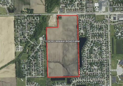
72 Acre Laraway Road Farm
| Status: | Active |
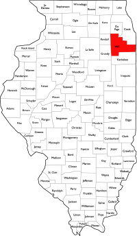
| County: | Will |
| Township: | New Lenox |
| Address: | W Laraway Road New Lenox IL 60451 |
| Gross Land Area: | 72.48 acres |
| Hectare Conversion | |
| Property Type: | Agricultural Farmland |
| Possible Uses: | Agricultural Production, Possible Development |
| Total Investment: | $4,276,320.00 |
| Monetary Conversion | |
| Unit Price: | $59,000/acre |
| Productivity Index (PI): | 124.8 |
| Buildings: | Ranch home on the property |
| Utilities: | Available in area |
| Zoning: | Currently zoned A-1, Comprehensive plan will allow residential development |
For more information contact:
Mark Goodwin
1-815-741-22261-815-741-2226 mgoodwin@bigfarms.com
Goodwin & Associates Real Estate, LLC
is an AGENT of the SELLERS.
property alerts
Be alerted to new listings, changes in current listings, and closings as a way to keep your finger on the pulse of the land market.
Property Overview
72 acres with frontage on W Laraway Road in New Lenox. Great visibility for your residential development project. The Village of New Lenox Comprehensive Plan designates this corridor for residential growth, and the 2005 Laraway Road Transit Village Plan specifically envisions transit-oriented development in this area. New Lenox Grade Schools (SD 122) and Lincoln-Way High School (CHSD 210).
The south side of New Lenox presents an excellent opportunity for residential development, offering a desirable blend of open space, strong community appeal, and convenient access to major transportation routes like I-80 and I-355. With top-rated schools, expanding local amenities, and a growing demand for new housing, this area is ideal for families and developers alike. There are two New Lenox Metra station. The Laraway road station is approximately1.5 miles east and the second is near the center of New Lenox at Cedar and Rt. 30 is approximately 3.5 miles to the northeast, providing direct commuter rail service to downtown Chicago.
W Laraway Road carries approximately 8,700 vehicles per day along the property frontage, increasing to 9,700 vehicles per day just east of Nelson Road. Nelson Road, running north-south adjacent to the property, carries approximately 2,950 vehicles per day. The I-80 and I-355 interchange, located approximately 5 miles to the north, handles over 48,000 vehicles per day.
The property features high-quality soils with a productivity index of 124.8, predominantly Elliott and Ashkum soil types, providing strong agricultural income during the planning and entitlement process. Approximately 71.33 tillable acres are currently in row crop production. No wetlands and no flood plain restrictions.
+ View Brochure
+ View Property Disclaimer and Disclosure.
 |
Property Notes
New Lenox, IL Demographics - Census Reporter
Village of New Lenox, IL - What's New
Village of New Lenox, IL - Community Redevelopment
Village of New Lenox, IL - Comprehensive Plan (PDF)
Village of New Lenox, IL - Zoning Map (PDF)
Village of New Lenox, IL - Maps & Resources
Property Map
Listing Details
General Information |
||
| Listing Name: | 72 Acre Laraway Road Farm | |
| Tax ID Number/APN: | 15-08-32-200-004-0000 (farmland) 15-08-32-200-002-0000 (House on half acre) |
|
| Possible Uses: | Continued Agricultural Use, Possible Development | |
| Zoning: | Currently Zoned A-1, Agriculture. The New Lenox Comprehensive plan calls for residential development. | |
Area & Location |
||
| School District: | New Lenox SD 122 (P-8) Lincoln Way CHSD 210 (9-12) | |
| Market Type: | Tapestry Segments: Professional Pride Savvy Suburbanites Workday Drive |
|
| Location Description: | This property is located on the south side of W Laraway Road, in New Lenox Township, New Lenox, IL. The site is between two established subdivisions. There is over 800 feet of frontage along Laraway road for excellent exposure to the general public. | |
| Site Description: | This 72-acre parcel runs north and south with frontage on W Laraway Road along the southern boundary. The farm is located between two established residential subdivisions. The land is predominantly level to gently rolling with clean boundaries. Approximately 71.33 tillable acres currently in row crop production. No wetlands with a small area of flood plain. See included maps for soil, topography, and environmental details. There is a pipeline easement along the west boundray line. | |
| Side of Street: | This property is located on the south side of W Laraway Road. | |
| Highway Access: | I-355 is located approximately 6.7 miles to the north. I-80 is located approximately 4 miles to the north. Route 30 is located about 2.5 miles to the north. Route 45 is located about 6 miles to the east. Route 52 is approximately 2 miles west. The property benefits from excellent highway connectivity, making it ideal for both agricultural operations and future development. Daily traffic counts: W Laraway Road carries approximately 8,700 vehicles per day at the property frontage, increasing to 9,700 vehicles per day to the east. Nelson Road carries approximately 2,950 vehicles per day. Please see the Daily Traffic Count Map included in the property gallery. |
|
| Road Type: | W Laraway Road is a paved road. All surrounding roads are of blacktop/asphalt construction. | |
| Legal Description: | PART OF THE NW1/4 NE1/4; SW1/4 NE1/4 OF SECTION 32, TOWNSHIP 35 NORTH, 11 EAST, WILL COUNTY, ILLINOIS | |
| Property Visibility: | Excellent visibility from W Laraway Road. The property's prime frontage location along this well-traveled road provides high visibility to passing traffic. Excellent visibility from W Laraway Road, which carries approximately 8,700 vehicles per day along the property's 2,640 feet of frontage. Traffic volume increases to 9,700 vehicles per day east of Nelson Road. The property's prime frontage location along this well-traveled road provides high visibility to passing traffic and strong exposure for future residential development. |
|
| Largest Nearby Street: | W Laraway Road. Laraway road is being improve to four lane from Rt. 52 to Frankfort. | |
| Transportation: | The New Lenox Metra Train Station is located approximately 3.5 miles to the northeast at Cedar and Rt. 30. The second Metra station is 1.5 mile east on Laraway road. Chicago Midway Airport is located about 36 miles to the north. Chicago O'Hare Airport is located about 45 miles to the north. | |
Land Related |
||
| Lot Frontage (Feet): | Approximately 823 feet of frontage on W Laraway Road. | |
| Yield History: | Strong historical yields consistent with high-quality farmland. Property has been well-managed for row crop production with corn and soybean rotation. | |
| Tillable Acres: | Approximately 71.33 acres tillable | |
| Lot Depth: | Approximately 2,570 feet | |
| Buildings: | Ranch home on the property. | |
| Zoning Description: | Currently Zoned: A-1, Agriculture New Lenox Comprehensive Plan allows future residential development opportunity. |
|
| Flood Plain or Wetlands: | There is a small area of flood plain near the south end of the parcel. Please see the FEMA Report and Wetland Map that is included, provided by Surety Maps. | |
| Topography: | Please see the topographical maps that are included, provided by Surety Maps. | |
| FSA Data: | FSA Map is included with this brochure. |
|
| Soil Type: | 53.5% Elliott silt loam, 2 to 4 percent slopes (146B) 37.1% Ashkum silty clay loam, 0 to 2 percent slopes (232A) 4.4% Elliott silty clay loam, 2 to 4 percent slopes, eroded (146B2) 2.2% Symerton silt loam, 2 to 5 percent slopes (294B) 1.9% Symerton silt loam, 5 to 10 percent slopes, eroded (294C2) 0.9% Varna silt loam, 4 to 6 percent slopes, eroded (223C2) For more information, please see the Soil Map that is included, provided by Surety Maps. |
|
| Available Utilities: | Would be available from the Village of New Lenox. | |
Financials |
||
| Finance Data Year: | 2024 Tax Year, Payable 2025 | |
| Real Estate Taxes: | 2024 Real Estate Taxes: PIN 15-08-32-200-004-0000: $4,062.42 (farmland) PIN 15-08-32-200-002-0000: $3,838.82 (house on half acre) Total Annual Taxes: $7,901.24 |
|
| Investment Amount: | Asking price is $59,000 per acre for a total investment of $4,276,320. | |
Location |
||
| Address: | W Laraway Road, New Lenox, IL 60451 | |
| County: | Will | |
| MSA: | Chicago-Naperville-Elgin, IL-IN-WI Metropolitan Statistical Area | |
MARK GOODWIN PROFESSIONAL BIOGRAPHY
It is difficult to find a real estate professional that specializes in Illinois Land Brokerage. Our services area includes Kendall County, Grundy County, Kane County, LaSalle County, Kankakee County, Livingston County, Ford County,Bureau, Henry County, Kane County, Dekalb County, Lake County, Iroquois County, Vermilion County, Kankakee County, and Cook County. Illinois Land Brokerage is a very specialized segment of the real estate brokerage industry. Knowledgeable Land Brokers are difficult to find. Many agents can sell a farm, but how many have the experience and qualifications of Goodwin and Associates?
Mark Goodwin is a Illinois Land Broker who can advise you about your land asset. It takes an experienced Illinois Land Broker to understand how best to market your land asset or find the property that best fits the investors needs or desires. Goodwin and Associates is the Land Broker for you in Illinois. We can help you with the marketing of your farm, residential development land, industrial land and commercial land or help with the selection of farmland, commercial land, retail land, industrial land, residential development land, residential lots, industrial lots and commercial lots. We are here to help you reach your goals.

Mark Goodwin - Illinois Land Broker
1-815-741-22261-815-741-2226 mgoodwin@bigfarms.com
Goodwin & Associates Real Estate, LLC
is an AGENT of the SELLERS.