63 AC New Lenox Farm
| Status: | Active |
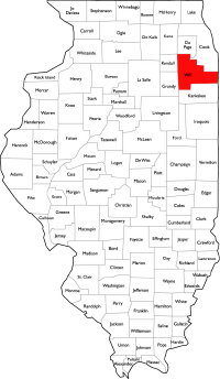
| County: | Will |
| Township: | New Lenox |
| Gross Land Area: | 63.00 |
| Hectare Conversion | |
| Property Type: | Vacant Farm Land with Development Potential |
| Possible Uses: | Agricultural Production, Possible Development |
| Total Investment: | $3,471,050 |
| Monetary Conversion | |
| Unit Price: | $55,000 for 57 acres and $65,000 for the 5 acre strip |
| Productivity Index (PI): | 119.4 |
| Buildings: | No Buildings |
| Utilities: | Natural Gas, Electric, Water and Sewer Are Available |
| Zoning: | Currently Zoned A-1, Agriculture |
For more information contact:
Mark Goodwin
1-815-741-22261-815-741-2226 mgoodwin@bigfarms.com
Goodwin & Associates Real Estate, LLC
is an AGENT of the SELLERS.
property alerts
Be alerted to new listings, changes in current listings, and closings as a way to keep your finger on the pulse of the land market.
Property Overview
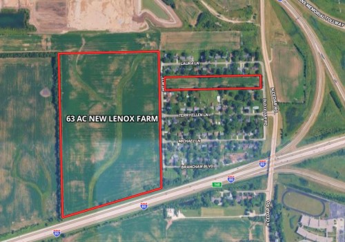
63 acre parcel currently being farmed but adjacent to Silver
Cross Hospital in New Lenox. The recently opened Crossroads Sports Complex is
just north of this parcel. Additional acreage is available up to 200 acres. Utilities, natural gas, electric, water, and sewer are
available from the Village of New Lenox. Key highlights include 1,504 feet of
I-80 frontage for added visibility, plus direct access to Cedar Road. Rt.
6 (Maple St.) is just 1/2 of a mile North and I-355 is just 3/4 of a mile North.
The area is exploding with new growth.
This property sits in the heart of New Lenox Township, a rapidly growing area that balances rural charm with metropolitan accessibility. Located just seconds from I-80, I-355, and US Route 6—plus within 2.2 miles of US Route 30 and near both Metra rail and Pace bus stations—the farm offers unbeatable transportation links for commuters, residents, and businesses alike. Students benefit from the excellent New Lenox SD 122 school system (elementary–middle) and Lincoln Way High School District 210, both highly regarded for academics and community support. The region’s stable farmland values, pro-growth environment, and proximity to one of Chicagoland’s strongest suburban markets make this farm a smart investment—whether for immediate farming income, land banking, or future residential or commercial development opportunities.
+ View Brochure
+ View Property Disclaimer and Disclosure.
 |
Property Map
Listing Details
General Information |
||
| Listing Name: | 63 AC New Lenox Dunn Farm | |
| Tax ID Number/APN: | 5.17 Acres: 15-08-09-202-015-0000 56.57 Acres: 15-08-09-200-004-0000 North side of I-80. (56.57 acre parcel is subdivided from larger 94.88 acre parcel) |
|
| Possible Uses: | Continued Agricultural Production, Possible Residential or Commercial Development | |
| Zoning: | Currently Zoned A-1, Agriculture. This parcel will need to be annexed into the Village of New Lenox to access utilities. | |
Area & Location |
||
| School District: | New Lenox SD 122 (P-8) Lincoln Way CHSD 210 (9-12) |
|
| Location Description: | This property is located in the City of New Lenox, New Lenox Township, in Will County, IL, just southeast from Silver Cross Hospital, along the north side of I-80, just west of the I-80/I-355 interchange and south of the I-355 access at Rt. 6 (Maple St.) | |
| Site Description: | This site is the rectangular parcel located on the north side of I-80. It has no buildings, a riverine that forks through the middle of the property, a tree line on the south and east property lines, and some electrical transmission towers located on the north side of the property running east and west. There is also a small five acre section to the east of the larger parcel that runs through an older residential development giving you access to Cedar road. | |
| Side of Street: | This property is located on the north side of I-80 and on the west side of N Cedar Road. | |
| Highway Access: | This property has a great location for highway access, with nearly immediate access to I-80, I-355, and US Route 6/Maple Road. US Route 30 is located about 2.2 miles to the southwest of the property. | |
| Road Type: | All surrounding roads are constructed from asphalt/blacktop. | |
| Legal Description: | NW1/4 NE1/4; PART OF THE NE1/4 NE1/4; PART OF THE SW1/4 NE1/4 OF SECTION 9, TOWNSHIP 35 NORTH, 11 EAST, WILL COUNTY, ILLINOIS | |
| Property Visibility: | This property is visible from I-80. | |
| Largest Nearby Street: | The largest street is US Route 6/Maple Road. | |
| Transportation: | The Metra Train Station is located 1.8 miles to the south. There is a Pace Bus Station located about 2.2 miles away at the Silver Cross Medical Office Building. Midway Airport is located about 31.5 miles to the northeast. O'Hare Airport is located about 40 miles to the north. |
|
Land Related |
||
| Lot Frontage (Feet): | This property has approximately 1,504 feet of frontage on the westbound side of I-80. There is a small portion of frontage, 163 feet, on N Cedar Road on the five acre parcel. | |
| Tillable Acres: | There are approximately 57.55 tillable acres between both parcels. | |
| Buildings: | There are no buildings on this property. | |
| Zoning Description: | Currently Zoned A-1, Agriculture | |
| Flood Plain or Wetlands: | There is a Riverine on approximately 1.1 acres of the main parcel. For more details, please see the included Wetland Map and FEMA Report provided by Surety Maps. | |
| Topography: | For topography details, please see the multiple included topographical maps provided by Surety Maps. | |
| Soil Type: | 38.4% Markham silt loam, 4 to 6 percent slopes, eroded (531C2) 32.7% Ashkum silty clay loam, 0 to 2 percent slopes (232A) 16.9% Elliott silt loam, 2 to 4 percent slopes (146B) 12.0% Beecher silt loam, 2 to 4 percent slopes (298B) For more details, please see the included Soil Map provided by Surety Maps. |
|
| Available Utilities: | Natural Gas, Electric, Water and Sewer Are Available | |
Financials |
||
| Finance Data Year: | 2023 Tax Year, Payable 2024 | |
| Real Estate Taxes: | 56.57 Acre Parcel: $32.38 per acre -or- $1,831.86 (estimated) 5.17 Acre Parcel: $176.90 Estimated Combined Total: $2,008.76 |
|
| Investment Amount: | $3,471,050.00 or $55,000 per acre for the 57 acres and $65,000 for the 5 acre access strip. | |
Location |
||
| Address: | New Lenox, IL 60451 | |
| County: | Will County, IL | |
MARK GOODWIN PROFESSIONAL BIOGRAPHY
It is difficult to find a real estate professional that specializes in Illinois Land Brokerage. Our services area includes Kendall County, Grundy County, Kane County, LaSalle County, Kankakee County, Livingston County, Ford County,Bureau, Henry County, Kane County, Dekalb County, Lake County, Iroquois County, Vermilion County, Kankakee County, and Cook County. Illinois Land Brokerage is a very specialized segment of the real estate brokerage industry. Knowledgeable Land Brokers are difficult to find. Many agents can sell a farm, but how many have the experience and qualifications of Goodwin and Associates?
Mark Goodwin is a Illinois Land Broker who can advise you about your land asset. It takes an experienced Illinois Land Broker to understand how best to market your land asset or find the property that best fits the investors needs or desires. Goodwin and Associates is the Land Broker for you in Illinois. We can help you with the marketing of your farm, residential development land, industrial land and commercial land or help with the selection of farmland, commercial land, retail land, industrial land, residential development land, residential lots, industrial lots and commercial lots. We are here to help you reach your goals.

Mark Goodwin - Illinois Land Broker
1-815-741-22261-815-741-2226 mgoodwin@bigfarms.com
Goodwin & Associates Real Estate, LLC
is an AGENT of the SELLERS.