
1027± AC Riverdale Farm
| Status: | Active |
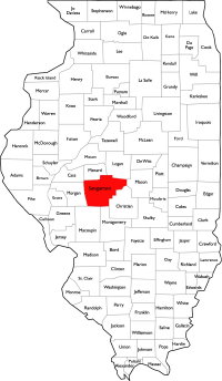
| County: | Sangamon |
| Township: | Williams |
| Address: | 0 Pine Dr Sherman IL 62684 |
| Gross Land Area: | 1027.6 total acres |
| Hectare Conversion | |
| Property Type: | Farmland and Timber |
| Possible Uses: | Row crop, recreation/hunting, development |
| Total Investment: | $12,050,000 |
| Monetary Conversion | |
| Unit Price: | $11,726.70 per acre |
| Productivity Index (PI): | 132.8 |
| Buildings: | None |
| Utilities: | Electric & natural gas nearby (Ameren Illinois); well & septic typical |
| Zoning: | A - Agricultural (Sangamon County) |
For more information contact:
Mark Goodwin
1-815-741-22261-815-741-2226 mgoodwin@bigfarms.com
Goodwin & Associates Real Estate, LLC
is an AGENT of the SELLERS.
property alerts
Be alerted to new listings, changes in current listings, and closings as a way to keep your finger on the pulse of the land market.
Property Overview
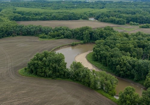
Offered for the first time in generations — 1,027± acres of Sangamon River bottom farmland, timber, and recreational ground assembled in fourteen tax parcels near the Village of Sherman, immediately north of Springfield on the I-55 corridor.
- 1,027± tax-record acres in 14 parcels; final acreage by survey
- ~646 tillable acres carrying a 132.8 weighted PI
- Productive Tice, Sawmill, Rozetta, Proctor & Lawson silt loam soils
- Extensive Sangamon River frontage with timbered river-bottom cover — outstanding deer & waterfowl habitat
- Adjoins the Village of Sherman and the I-55 right-of-way; Exit 105 approx 1.7 miles
- Long-term development opportunity on the unincorporated ground along Sherman’s growth corridor
- All seller-owned mineral rights convey; possession at closing
The farm’s ~646 tillable acres are led by Tice, Sawmill, Rozetta, Proctor, and Lawson silt loams carrying a weighted Productivity Index of 132.8 on the tillable ground. The balance is timbered Sangamon River bottom and mixed cover that hunts as well as it farms. River-bottom acreage lies in FEMA Zones AE/A, with roughly 22% of the farm in Zone X (minimal flood hazard); elevations run 505.6–579.5 feet.
Location is the difference-maker: the property adjoins the Village of Sherman and fronts the I-55 right-of-way, with the Sherman interchange (Exit 105) approx 1.7 miles away, downtown Springfield approx 6.3 miles, and Abraham Lincoln Capital Airport approx 5.4 miles. St. Louis is approx 92 miles and Chicago approx 172 miles via I-55.
With Sherman’s residential edge bordering the northern parcels, the unincorporated acreage presents a genuine long-term development opportunity while producing farm income today — income, recreation, and appreciation in a single holding.
+ View Brochure
+ View Property Disclaimer and Disclosure.
 |
Property Video
Property Notes
Property Facts
- 1,027.6± acres per Sangamon County tax records (14 PINs); final acreage by survey
- ~646 tillable acres (Surety AgriData); PI 132.8
- Primary soils: Tice, Sawmill, Rozetta, Proctor & Lawson silt loams
- 2025 real estate taxes: $28,713.08 total (13 of 14 parcels; final PIN's bill pending)
- Townships: Williams, Clear Lake, Fancy Creek & Springfield
- FEMA: river-bottom acreage Zones AE/A; ~22% Zone X (panels 17167C0100F & 17167C0255F, eff. 8/2/2007)
- Elevation 505.6–579.5 ft; average slope 3.5%
- No buildings; all seller-owned mineral rights convey
Location & Distances (approx, straight-line)
- Village of Sherman — 1.4 mi
- I-55 Exit 105 (Sherman) — 1.7 mi
- Abraham Lincoln Capital Airport (SPI) — 5.4 mi
- Springfield Amtrak station — 6.2 mi
- Downtown Springfield — 6.3 mi
- St. Louis — 92 mi · Chicago — 172 mi
Local Resources
Property Map
Listing Details
General Information |
||
| Listing Name: | 1,027.6± AC Riverdale Farm, Sangamon County, Sherman Illinois. | |
| Tax ID Number/APN: | 07-31.0-100-005 (Williams Twp) - 59.44 acres 07-31.0-100-006 (Williams Twp) - 80.00 acres 07-31.0-200-001 (Williams Twp) - 80.00 acres 07-31.0-200-002 (Williams Twp) - 80.00 acres 07-31.0-300-002 (Williams Twp) - 231.91 acres 07-31.0-400-001 (Williams Twp) - 80.00 acres 07-32.0-100-001 (Williams Twp) - 80.00 acres 07-32.0-300-002 (Williams Twp) - 1.00 acres 15-05.0-100-001 (Clear Lake Twp) - 69.91 acres 15-06.0-100-008 (Clear Lake Twp) - 2.57 acres 15-06.0-100-009 (Clear Lake Twp) - 84.57 acres 15-06.0-200-003 (Clear Lake Twp) - 128.50 acres 06-36.0-400-027 (Fancy Creek Twp) - 30.08 acres 14-01.0-200-006 (Springfield Twp) - 19.59 acres Total: 1,027.57 acres (14 parcels, per county tax records) |
|
| Possible Uses: | Row-crop production, recreational/hunting, pasture, long-term development opportunity | |
| Zoning: | A - Agricultural (Sangamon County) | |
| Sale Terms: | Cash at closing. Boundary survey at Seller's expense; final purchase price based upon surveyed acres. All seller-owned water, oil, gas, coal and mineral rights convey. | |
Area & Location |
||
| School District: | Williamsville-Sherman CUSD 15 (Sherman area) - Sherman Elementary School (PK-4), Williamsville Junior High School (5-8), Williamsville High School (9-12) | |
| Market Type: | Springfield, IL metro | |
| Location Description: | Adjoining the Village of Sherman on the I-55 corridor, immediately north of Springfield. The farm wraps both sides of the I-55 right-of-way through Sections 31 and 32 of Williams Township, with the Sangamon River forming its southern reaches. Sherman interchange (Exit 105) approx 1.7 miles; downtown Springfield approx 6.3 miles. | |
| Site Description: | Sangamon River bottom farm combining ~646 tillable acres with timbered river-bottom cover, sloughs, and mixed habitat. No buildings. | |
| Side of Street: | East side of Pine Dr (Historic US 66); the farm lies on both sides of the I-55 right-of-way | |
| Highway Access: | Direct I-55 corridor location; nearest interchange I-55 Exit 105 (Sherman / Historic US 66 / Business Loop 55), approx 1.7 miles. Business Loop 55 connects south through Sherman to downtown Springfield. | |
| Road Type: | Paved frontage via Pine Dr (Historic US 66 frontage road); township road access to outlying parcels | |
| Legal Description: | PT NWNW; PT NENW; PT SWNW; PT SENW 5-16N-4W AND PT NWNW; NENW; N2NE; PT SENW; PT SWNE; SENE; PT NESE 6-16N-4W AND PT NENE; PT SENE 1-16N-5W AND PT NWNW; E2NW; E2; PT SWNW; PT NWSW; E2SW; PT SWSW 31-17N-4W AND W2NW 32-17N-4W AND PT NESE; PT SESE 36-17N-5W - Sangamon County, Illinois. Complete legal available from listing broker. | |
| Property Visibility: | Extensive I-55 corridor exposure through Sections 31/32 | |
| Largest Nearby Street: | Interstate 55 | |
| Transportation: | Amtrak - Springfield station (Lincoln Service & Texas Eagle), approx 6.2 mi. Abraham Lincoln Capital Airport (SPI), approx 5.4 mi. St. Louis approx 92 mi and Chicago approx 172 mi via I-55. | |
Land Related |
||
| Lot Frontage (Feet): | Irregular multi-parcel boundary; frontage to be determined by survey | |
| Yield History: | FSA Program (PLC) Yield — Corn: 141 bu/ac; Soybeans: 42 bu/ac (Farm 3156/Tract 2104 base yield per FSA farm records; not a representation of actual harvest yields). | |
| Tillable Acres: | ~646 (Surety AgriData) | |
| Lot Depth: | Irregular; to be determined by survey | |
| Buildings: | None | |
| Zoning Description: | A - Agricultural District, Sangamon County Zoning Ordinance (1969, as amended); no variances or rezonings on file | |
| Flood Plain or Wetlands: | River-bottom acreage in FEMA Zones AE/A (incl. regulatory floodway along the Sangamon River); ~22% of the farm in Zone X (minimal hazard). FEMA panels 17167C0100F & 17167C0255F, effective 8/2/2007. | |
| Topography: | Elevation 505.6-579.5 ft (73.9 ft of relief); average slope 3.5%. Level river-bottom fields rising to rolling timbered breaks. | |
| FSA Data: | FSA Farm 3156 / Tract 2104 (2026 program year): Farmland 1,048.40 ac; Cropland (DCP) 647.80 ac; Farm Status Active. Base acres — Corn: 537.22 ac (PLC Yield 141 bu/ac); Soybeans: 110.58 ac (PLC Yield 42 bu/ac). HEL field with conservation system actively applied; tract contains a wetland/farmed wetland; ARCPLC eligible; no CRP contracts. Complete FSA farm records included in this brochure. | |
| Soil Type: | Tice silty clay loam (37.6%), Sawmill silty clay loam (24.8%), Rozetta silt loam (9.6%), Proctor silt loam (5.5%), Lawson silt loam (4.2%), balance mixed silt loams | |
| Available Utilities: | Electric & natural gas in the Sherman area (Ameren Illinois); well & septic typical on rural parcels | |
Financials |
||
| Finance Data Year: | 2025 | |
| Real Estate Taxes: | $28,713.08 (2025, payable 2026; 13 of 14 parcels — PIN 07-32.0-300-002's bill not yet available). Estimated real estate taxes ~ $27.94 per acre (based on 1,027.57± acres). | |
| Investment Amount: | $12,050,000.00 ($11,726.70 per acre) | |
Location |
||
| Address: | 0 Pine Dr, Sherman, IL 62684 | |
| County: | Sangamon | |
| MSA: | Springfield, IL | |
MARK GOODWIN PROFESSIONAL BIOGRAPHY
It is difficult to find a real estate professional that specializes in Illinois Land Brokerage. Our services area includes Kendall County, Grundy County, Kane County, LaSalle County, Kankakee County, Livingston County, Ford County,Bureau, Henry County, Kane County, Dekalb County, Lake County, Iroquois County, Vermilion County, Kankakee County, and Cook County. Illinois Land Brokerage is a very specialized segment of the real estate brokerage industry. Knowledgeable Land Brokers are difficult to find. Many agents can sell a farm, but how many have the experience and qualifications of Goodwin and Associates?
Mark Goodwin is a Illinois Land Broker who can advise you about your land asset. It takes an experienced Illinois Land Broker to understand how best to market your land asset or find the property that best fits the investors needs or desires. Goodwin and Associates is the Land Broker for you in Illinois. We can help you with the marketing of your farm, residential development land, industrial land and commercial land or help with the selection of farmland, commercial land, retail land, industrial land, residential development land, residential lots, industrial lots and commercial lots. We are here to help you reach your goals.

Mark Goodwin - Illinois Land Broker
1-815-741-22261-815-741-2226 mgoodwin@bigfarms.com
Goodwin & Associates Real Estate, LLC
is an AGENT of the SELLERS.