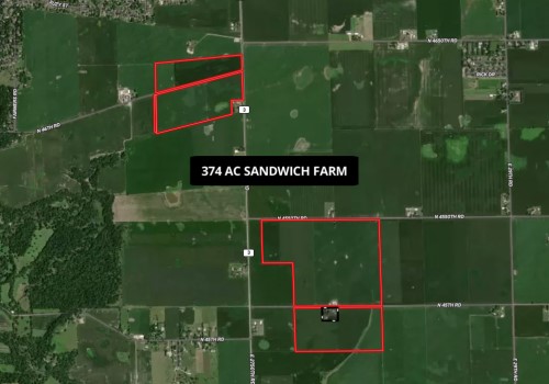
374 AC Sandwich Farm
| Status: | Active |
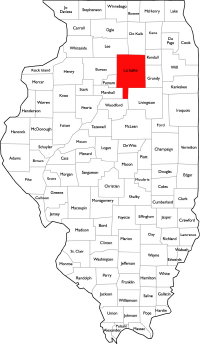
| County: | LaSalle |
| Township: | Northville |
| Address: | N 4550th Rd & E 2750th Rd Sandwich IL 60548 |
| Gross Land Area: | 374 Total acres |
| Hectare Conversion | |
| Property Type: | Agricultural Farmland |
| Possible Uses: | Agricultural Production, Possible Development |
| Total Investment: | $6,732,000.00 |
| Monetary Conversion | |
| Unit Price: | $18,000.00 per acre |
| Productivity Index (PI): | 139.7 |
| Buildings: | House & buildings are not part of this sale. Sheds across the street are included. |
| Zoning: | A-1, Agriculture |
For more information contact:
Mark Goodwin
1-815-741-22261-815-741-2226 mgoodwin@bigfarms.com
Goodwin & Associates Real Estate, LLC
is an AGENT of the SELLERS.
property alerts
Be alerted to new listings, changes in current listings, and closings as a way to keep your finger on the pulse of the land market.
Property Overview
The 374-acre Sandwich Farm is a premier LaSalle County agricultural holding comprised of two groups of large, contiguous tracts located just south of Sandwich, Illinois. With a weighted average soil productivity index of 139.7, the farm is exceptionally well-suited for row-crop production and offers scale and efficiency for modern operators.
The property features over 10,000 feet of combined hard-surfaced road frontage on N 4550th Rd, N 45th Rd, N 46th Rd, and E 2750th Rd, providing excellent visibility and access. Topography is level to gently rolling, with nearly all acres tillable and minimal impact from wetlands or floodplain.
In addition to its strong agricultural fundamentals, the farm holds long-term development potential given its location along the Sandwich–Yorkville growth corridor, with convenient access to US Highway 34, Illinois Routes 47 & 71, and regional interstates. This combination of scale, soil quality, and location makes the Sandwich Farm an attractive acquisition for farmers, investors, or developers alike.
+ View Brochure
+ View Property Disclaimer and Disclosure.
 |
Property Map
Listing Details
General Information |
||
| Listing Name: | 374 AC Sandwich Farm | |
| Tax ID Number/APN: | PIN 05-23-100000 – 40.0 acres PIN 05-22-201000 – 40.0 acres PIN 05-14-300000 – 80.0 acres PIN 05-15-402000 – 108.0 acres PIN 05-10-303000 – 109.6 acres Combined Total of All Parcels: 377.6 acres |
|
| Possible Uses: | Agricultural Production, Development Potential | |
| Zoning: | A-1 Agricultural | |
| Sale Terms: | Seller is keeping the house and farm buildings found on the south side of N 45th Rd. Buildings on the North side of 45th road are being sold with the farm. | |
Area & Location |
||
| School District: | Sandwich CUSD 430 (PreK–12) | |
| Location Description: | The 374-acre Sandwich Farm consists of two separate but nearby tracts located south of Sandwich in LaSalle County, Illinois. Northern Group (approx. 109 acres): Located on both sides of N 46th Rd, between N 4650th Rd and N 4550th Rd. This block features large contiguous fields with excellent road frontage and access. Southern Group (approx. 263 acres ): Located south of N 4550th road and frontage on the north and south sides of N 45th road. This tract includes broad, open fields with rectangular field layouts and road frontage on multiple sides. The two tracts are separated by approximately 0.5–1 mile, connected via the local county road system, and collectively form a substantial contiguous landholding well-suited for modern farming operations. |
|
| Site Description: | The property is primarily row-crop farmland, consisting of highly productive silty clay loams and silt loams with a weighted average PI of 139.7. The fields are large, rectangular, and highly efficient for modern equipment, with nearly all acres tillable. Topography is gently rolling with good natural drainage, and wetland/floodplain mapping indicates minimal impact on operations. Road access and visibility are strong. The Sandwich Farm offers scale and efficiency for row-crop operators while holding long-term value for future development opportunities given its proximity to Sandwich and Yorkville growth corridors. |
|
| Side of Street: | Northern group fronts both sides of N 46th Rd with frontage along E 2750th road. Southern group fronts both sides of N 45th Rd and south side of N4550th Rd. |
|
| Highway Access: | Convenient access to US Highway 34, Illinois Route 47, and Illinois Route 71. Interstates I-80 and I-88 are accessible within a short drive, providing direct connections to the Chicago metropolitan area. | |
| Road Type: | Asphalt-paved county roads (E 2750th Rd). Township roads are gravel. | |
| Legal Description: | PART OF THE NW1/4 SW1/4; PART OF THE NE1/4 SW1/4; PART OF THE SW1/4 SW1/4; PART OF THE SE1/4 SW1/4 OF SECTION 10, TOWNSHIP 36 NORTH, 5 EAST, LASALLE COUNTY, ILLINOIS AND W1/2 SW1/4 OF SECTION 14, TOWNSHIP 36 NORTH, 5 EAST, LASALLE COUNTY, ILLINOIS AND PART OF THE NW1/4 SE1/4; E1/2 SE1/4 OF SECTION 15, TOWNSHIP 36 NORTH, 5 EAST, LASALLE COUNTY, ILLINOIS AND PART OF THE NE1/4 NE1/4 OF SECTION 22, TOWNSHIP 36 NORTH, 5 EAST, LASALLE COUNTY, ILLINOIS AND NW1/4 NW1/4 OF SECTION 23, TOWNSHIP 36 NORTH, 5 EAST, LASALLE COUNTY, ILLINOIS |
|
| Property Visibility: | There is a tremendous amount of road frontage for all these farm parcels. | |
| Largest Nearby Street: | US Highway 34 (Sandwich to Plano corridor), approx. 2–3 miles north. Illinois Route 47 also accessible within minutes. | |
| Transportation: | Freight/Highway: US-34, IL-47, IL-71; access to I-88 / I-80 corridors. Rail/Commuter: Nearest Metra service via Aurora (BNSF Line); regional Amtrak service via Mendota. Air: Chicago O’Hare & Midway (regional access); Aurora Municipal (ARR) for general aviation. |
|
Land Related |
||
| Tillable Acres: | Majority tillable; maps indicate strong field continuity with approximately 363.64 tillable acres. | |
| Buildings: | House and building site on the south side of 45th road are NOT included with this sale. (Tax ID# 05-22-201000). Buildings on the north side of 45Th Rd are included (Tax ID# 05-15-402000) | |
| Zoning Description: | A-1, Agricultural (LaSalle County) | |
| Flood Plain or Wetlands: | FEMA: 100% Zone X – Area of Minimal Flood Hazard (outside 500-yr floodplain). Wetlands (NWI): 1.87 acres Riverine (R4SBC) across the mapped boundary. Please see the included FEMA Report and Wetland Map, provided by Surety Maps, for further details. |
|
| Topography: | Elevation min ~628.5 ft, max ~669.4 ft, avg ~648.7 ft; range ~40.9 ft; contour interval 4 ft. Terrain is level to gently rolling—well suited to modern row-crop operations and efficient drainage. For details, please see the included topography maps provided by Surety Maps. | |
| FSA Data: | Farmland Acres 372.21 Cropland Acres 363.64 Corn Base: 182.5 with a PLC Yield of 180 bushels per acre. Soybean Base: 181.1 with a PLC Yield of 51 bushels per acre. |
|
| Soil Type: | 199B Plano silt loam (2–5%): 145.20 ac (39.8%), PI 141 152A Drummer silty clay loam (0–2%): 66.59 ac (18.3%), PI 144 154A Flanagan silt loam (0–2%): 57.62 ac (15.8%), PI 144 206A Thorp silt loam (0–2%): 19.14 ac (5.3%), PI 126 198A Elburn silt loam (0–2%): 18.42 ac (5.1%), PI 143 148C2 Proctor silt loam (5–10%, eroded): 17.89 ac (4.9%), PI 126 330A Peotone silty clay loam (0–2%): 11.86 ac (3.3%), PI 123 199C2 Plano silt loam (5–10%, eroded): 7.66 ac (2.1%), PI 132 679B Blackberry silt loam (2–5%): 6.19 ac (1.7%), PI 141 171B Catlin silt loam (2–5%): 5.37 ac (1.5%), PI 137 818A Flanagan-Catlin silt loams (0–3%): 4.20 ac (1.2%), PI 141 234A Sunbury silt loam (0–2%): 2.52 ac (0.7%), PI 131 61A Atterberry silt loam (0–2%): 0.98 ac (0.3%), PI 132 Weighted Average PI: 139.7. For details, please see the included Soil Map provided by Surety Maps. |
|
Financials |
||
| Finance Data Year: | 2023 Tax Year, Payable 2024 | |
| Real Estate Taxes: | PIN 05-23-100000 (40 ac): $1,762.88 PIN 05-22-201000 (40 ac): $5,862.60 PIN 05-14-300000 (80 ac): $4,285.40 PIN 05-15-402000 (108 ac): $5,740.06 PIN 05-10-303000 (109.6 ac): $5,789.16 Combined Total: $23,440.10 |
|
| Investment Amount: | Approximately 374 Acres subject to a survey. $18,000 per acre for a total investment of $6,732,000. | |
Location |
||
| Address: | N 4550th Rd & E 2750th Rd, Sandwich, IL 60548 | |
| County: | LaSalle County, IL | |
MARK GOODWIN PROFESSIONAL BIOGRAPHY
It is difficult to find a real estate professional that specializes in Illinois Land Brokerage. Our services area includes Kendall County, Grundy County, Kane County, LaSalle County, Kankakee County, Livingston County, Ford County,Bureau, Henry County, Kane County, Dekalb County, Lake County, Iroquois County, Vermilion County, Kankakee County, and Cook County. Illinois Land Brokerage is a very specialized segment of the real estate brokerage industry. Knowledgeable Land Brokers are difficult to find. Many agents can sell a farm, but how many have the experience and qualifications of Goodwin and Associates?
Mark Goodwin is a Illinois Land Broker who can advise you about your land asset. It takes an experienced Illinois Land Broker to understand how best to market your land asset or find the property that best fits the investors needs or desires. Goodwin and Associates is the Land Broker for you in Illinois. We can help you with the marketing of your farm, residential development land, industrial land and commercial land or help with the selection of farmland, commercial land, retail land, industrial land, residential development land, residential lots, industrial lots and commercial lots. We are here to help you reach your goals.

Mark Goodwin - Illinois Land Broker
1-815-741-22261-815-741-2226 mgoodwin@bigfarms.com
Goodwin & Associates Real Estate, LLC
is an AGENT of the SELLERS.