386 AC Combined Livingston County Farms
| Status: | Sold |
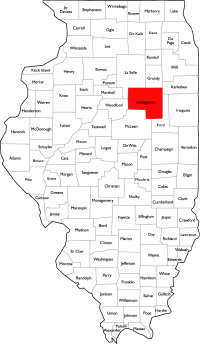
| County: | Livingston |
| Township: | Nevada & Newtown |
| Address: | E 3000 North Road Odell & Cornell IL |
| Gross Land Area: | 386 Acres |
| Hectare Conversion | |
| Property Type: | Vacant Agricultural Farmland |
| Possible Uses: | Agricultural Production |
| Total Investment: | $3,667,000 |
| Monetary Conversion | |
| Unit Price: | $9,500.00 per acre |
| Sold Price: | 3,384,551 |
| Productivity Index (PI): | 115.0 & 116.0 |
| Buildings: | No Buildings |
| Zoning: | A-1, Agriculture |
For more information contact:
Mark Goodwin
1-815-741-22261-815-741-2226 mgoodwin@bigfarms.com
Goodwin & Associates Real Estate, LLC
is an AGENT of the SELLERS.
property alerts
Be alerted to new listings, changes in current listings, and closings as a way to keep your finger on the pulse of the land market.
Property Overview
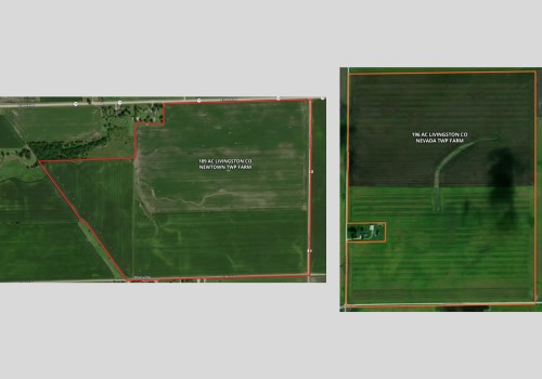
386± acres of high-quality cropland in Livingston County, split between a 196.7-acre tract near Odell (PIN 04-04-18-300-004) and a 189.2-acre tract near Cornell (PIN 02-02-21-200-005). Both parcels are nearly all tillable, with strong soil types (Bryce & Swygert silty clay loams dominate), level to gently rolling topography, and excellent access to major highways. The Odell parcel fronts a paved township road and is just minutes from I-55; the Manville parcel features frontage on Illinois Route 17. Excellent tenant in place willing to continue farming these parcels and work with the new owner.+ View Brochure
+ View Property Disclaimer and Disclosure.
 |
Property Map
Listing Details
General Information |
||
| Listing Name: | 386 AC Combined Livingston County Farms | |
| Tax ID Number/APN: | 196.7 Acre Parcel, Nevada Township: 04-04-18-300-004 189.2 Acre Parcel, Newtown Township: 02-02-21-200-005 |
|
| Possible Uses: | Agricultural Production | |
| Zoning: | A-1, Agricultural | |
Area & Location |
||
| School District: | 196.7 Acre Parcel (Odell): Odell CCSD 435 (P-8), Pontiac Twp HSD 90 (9-12) 189.2 Acre Parcel (Cornell): Woodland CUSD 5 (P-12) |
|
| Location Description: | 196.7 Acre Parcel Nevada Township: The property is located on E 3000 North Road, Odell, IL 60460, in Livingston County. It sits just west of Interstate 55, north of Odell, and can be easily located on maps between Dwight (10 miles north) and Pontiac (15 miles south). Access is from 3100 North Road, a paved country road providing direct connection to the interstate and surrounding communities. 189.2 Acre Parcel (Cornell): The property is situated on E 3000 North Road, Cornell, IL 61319, in Livingston County. It lies east of the village of Cornell along 3000 North Road, with access via rural township roads. The site is between Dwight (to the north) and Cornell (to the west), and lies within the 61319 postal area. The farm is next to Manville. The properties are approximately 10.4 miles apart (15-20 minutes drive time). |
|
| Site Description: | 196.7 Acre Parcel (Odell): The property consists of 196± contiguous acres located in Nevada Township, Livingston County, Illinois. The farm is primarily level to gently rolling cropland with a central drainage way, providing efficient field access and management. The tract is nearly all tillable with productive soils, suitable for corn and soybean rotations. A small farmstead is present at the southwest corner of the boundary but is not included in the sale. The land is bordered by well-maintained township roads, offering reliable access for equipment and transport. This property represents a sizable, well-shaped tract of farmland in a strong agricultural area, combining efficient field layout and excellent access. 189.2 Acre Parcel (Cornell): The property consists of 189± contiguous acres located in Newtown Township, Livingston County, Illinois. The farm features level to gently rolling cropland with good field drainage and efficient layout for modern equipment. Nearly all acres are tillable with productive soils well-suited for corn and soybean production. The tract has excellent road frontage along Illinois Route 17 on the north boundary and township roads on the east and south, providing multiple points of access. No building improvements are included in the sale. This farm represents a large, well-shaped tract of high-quality farmland with strong soil productivity and convenient access to major transportation routes. |
|
| Side of Street: | 196.7 Acre Parcel (Odell): This property is located on the north side of E 3000 North Road and the east side of N 1800 East Road. 189.2 Acre Parcel (Cornell): This property is located on the south side of IL-17/E 3000 North Road, the west side of N 900 East Road, and the north side of E 2950 North Road. |
|
| Highway Access: | 196.7 Acre Parcel (Odell): I-55 Odell Exit: ~6.5 miles I-55 Dwight Exit: ~8 miles I-55 Pontiac Exit: ~11 miles IL Route 17 (Dwight): ~8.5 miles IL Route 17 (Pontiac): ~9.5 miles US Route 24 (Pontiac): ~9.5 miles IL Route 116 (Pontiac): ~9.5 miles I-80 Morris Access: ~26 miles 189.2 Acre Parcel (Cornell): I-55 Odell Exit: ~10 miles I-55 Dwight Exit: ~18 miles I-55 Pontiac Exit: ~6 miles IL Route 17 (Pontiac): ~6 miles IL Route 17 (Dwight): ~18 miles US Route 24 (Pontiac): ~6 miles IL Route 116 (Pontiac): ~6 miles I-80 Morris Access: ~33 miles |
|
| Road Type: | Both properties have tar & chip roads, but the 189 acres in Newtown Township has frontage on State Highway 17. | |
| Legal Description: | 196.7 Acre Parcel (Odell): PART OF THE SE1/4 NE1/4; PART OF THE NE1/4 SE1/4; PART OF THE SE1/4 SE1/4 OF SECTION 13, TOWNSHIP 30 NORTH, 5 EAST, LIVINGSTON COUNTY, ILLINOIS AND PART OF THE SW1/4 NW1/4; PART OF THE SE1/4 NW1/4; N1/2 SW1/4; PART OF THE SW1/4 SW1/4; SE1/4 SW1/4 OF SECTION 18, TOWNSHIP 30 NORTH, 6 EAST, LIVINGSTON COUNTY, ILLINOIS 189.2 Acre Parcel (Cornell): PART OF THE NE1/4 NW1/4; PART OF THE NW1/4 NE1/4; E1/2 NE1/4; PART OF THE SE1/4 NW1/4; SW1/4 NE1/4 OF SECTION 21, TOWNSHIP 30 NORTH, 4 EAST, LIVINGSTON COUNTY, ILLINOIS AND PART OF THE NW1/4 NW1/4; PART OF THE SW1/4 NW1/4 OF SECTION 22, TOWNSHIP 30 NORTH, 4 EAST, LIVINGSTON COUNTY, ILLINOIS |
|
| Property Visibility: | 196.7 Acre Parcel (Odell): This property is visible from both E 3000 North Road and N 1800 East Road. 189.2 Acre Parcel (Cornell): This property is visible from IL-17/E 3000 North Road, N 900 East Road, and E 2950 North Road. |
|
| Largest Nearby Street: | 196.7 Acre Parcel (Odell): E 3000 North Road 189.2 Acre Parcel (Cornell): IL-17/E 3000 North Road |
|
| Transportation: | 196.7 Acre Parcel (Odell): Dwight Amtrak Station: ~8.6 miles Pontiac Amtrak Station: ~9.6 miles Bloomington-Normal Amtrak Station: ~41 miles 189.2 Acre Parcel (Cornell): Pontiac Amtrak Station: ~5.7 miles Dwight Amtrak Station: ~18 miles Bloomington-Normal Amtrak Station: ~33 miles |
|
Land Related |
||
| Lot Frontage (Feet): | 196.7 Acre Parcel (Odell): There is approximately 2,683 feet of frontage on E 3000 North Road and 3,324 on N 1800 East Road. 189.2 Acre Parcel (Cornell): There is approximately 2,205 feet of frontage on IL-17/E 3000 North Road, 2,619 feet of frontage on N 900 East Road, and 2,727 feet of frontage on E 2950 North Road. |
|
| Tillable Acres: | 196.7 Acre Parcel (Odell): 100% of this property is tillable acreage. 189.2 Acre Parcel (Cornell): There are approximately 179.04 tillable acres. |
|
| Buildings: | There are no buildings located on either property. | |
| Zoning Description: | Both properties are zoned as A-1, Agriculture | |
| Flood Plain or Wetlands: | 196.7 Acre Parcel (Odell): There are approximately 2.12 acres of Riverine that runs from the northeast corner through the middle of the property to just north of the southwest corner. 189.2 Acre Parcel (Cornell): There are no wetlands on this property. For detailed information, please see the FEMA Report and Wetland Maps for each property, provided by Surety Maps. |
|
| Topography: | 196.7 Acre Parcel (Odell): The farm features level to gently sloping topography, with elevations ranging from approximately 690 to 713 feet above sea level. The terrain is predominantly flat with slight undulations, providing excellent conditions for drainage and efficient field operations. With an elevation variance of just under 23 feet across the tract, the land is well suited for row crop production and supports modern farming equipment with minimal slope limitations. 189.2 Acre Parcel (Cornell): This farm is characterized by nearly level cropland with gentle elevation changes between approximately 597 and 624 feet above sea level. The elevation range of about 26 feet creates mild slopes that aid natural drainage without hindering tillage or planting. The tract’s smooth contours and consistent slope patterns make it highly workable and productive, with very little non-tillable ground. |
|
| FSA Data: | Newtown Twp: 183.76 Farmland Acres, 180.3 Cropland Acres. Corn Base: 99.4 acres with a PLC Yield of 142 Soybean Base: 80.8 acres with a PLC Yield of 45 Nevada Twp: 200.61 Farmland Acres, 196.92 Cropland Acres. Corn Base 103.2 acres with a PLC Yield of146 Soybean Base 91.3 acres with PLC Yield of 45 |
|
| Soil Type: | 196.7 Acre Parcel Nevada Township: 46.9% – Bryce silty clay (235A) 20.2% – Swygert silty clay loam, 0–2% slopes (91A) 17.9% – Swygert silty clay loam, 2–4% slopes, eroded (91B2) 9.8% – Clarence silty clay loam, 4–6% slopes, eroded (147C2) 4.4% – Rantoul silty clay, 0–2% slopes (238A) 0.8% – Mona silt loam, 2–5% slopes, eroded (448B2) Weighted Average PI: 116 189.2 Acre Parcel Newtown Township: 41.1% – Swygert silty clay loam, 0–2% slopes (91A) 37.5% – Bryce silty clay, 0–2% slopes (235A) 7.9% – Clarence silty clay loam, 0–2% slopes (147A) 6.2% – Clarence silty clay loam, 2–4% slopes, eroded (147B2) 4.3% – Monee silt loam, 0–2% slopes (229A) 1.2% – Mokena silt loam, 0–2% slopes (295A) 1.1% – Swygert silty clay loam, 2–4% slopes, eroded (91B2) 0.5% – Lawson silt loam, 0–2% slopes, frequently flooded (3451A) 0.2% – Milford silty clay loam, 0–2% slopes (69A) Weighted Average PI: 115 For details, please see the included Soil Map for each property, provided by Surety Maps. |
|
Financials |
||
| Finance Data Year: | 2024 Tax Year, Payable 2025 | |
| Real Estate Taxes: | 196.7 Acre Parcel (Odell): $6,416.36 189.2 Acre Parcel (Cornell): $6,254.50 Combined Total: $12,670.86 |
|
| Investment Amount: | $3,667,000.00 for both properties -or- $9,500.00 per acre |
|
Location |
||
| Address: | 196.7 Acre Parcel (Odell): E 3000 North Road, Odell, IL 60460 189.2 Acre Parcel (Cornell): E 3000 North Road, Cornell, IL 61319 |
|
| County: | Livingston County, IL | |
MARK GOODWIN PROFESSIONAL BIOGRAPHY
It is difficult to find a real estate professional that specializes in Illinois Land Brokerage. Our services area includes Kendall County, Grundy County, Kane County, LaSalle County, Kankakee County, Livingston County, Ford County,Bureau, Henry County, Kane County, Dekalb County, Lake County, Iroquois County, Vermilion County, Kankakee County, and Cook County. Illinois Land Brokerage is a very specialized segment of the real estate brokerage industry. Knowledgeable Land Brokers are difficult to find. Many agents can sell a farm, but how many have the experience and qualifications of Goodwin and Associates?
Mark Goodwin is a Illinois Land Broker who can advise you about your land asset. It takes an experienced Illinois Land Broker to understand how best to market your land asset or find the property that best fits the investors needs or desires. Goodwin and Associates is the Land Broker for you in Illinois. We can help you with the marketing of your farm, residential development land, industrial land and commercial land or help with the selection of farmland, commercial land, retail land, industrial land, residential development land, residential lots, industrial lots and commercial lots. We are here to help you reach your goals.

Mark Goodwin - Illinois Land Broker
1-815-741-22261-815-741-2226 mgoodwin@bigfarms.com
Goodwin & Associates Real Estate, LLC
is an AGENT of the SELLERS.